In this post, Jakob Wolfram talks about his most recent paper “Insecticide Risks in United States Surface Waters: Drivers and Spatiotemporal Modeling”. This publication analyzed the drivers of insecticide nonpoint source pollution and used a modelling approach to identify regions in the U.S. where surface waters may be at risk.
Insecticides remain widely used in U.S. agriculture to combat various pests; however these highly toxic chemicals also find their way into nontarget aquatic systems, impairing these ecosystems on the national scale (see this earlier blogpost). We used an extensive data set of 5830 measured insecticide concentrations (MICs) reported in the scientific literature to improve our understanding regarding the factors that promote MICs occurring above regulatory threshold levels (RTLs), thus adversely affecting ecosystem structure and function.
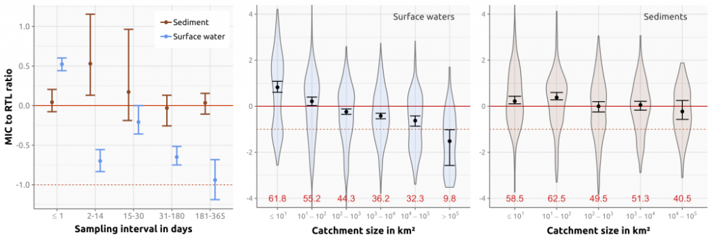
Our analyses revealed that spatio-temporal risk characteristics differed substantially between the water and sediment phase (see figure below). In sediments, risks were distributed rather evenly throughout space, such that only marginal differences were found between smaller and larger catchments, resulting in RTL exceedances of approximately 50% for these water body sizes. Similarly, monitoring strategies, i.e. the frequency and/or targeting of entry events, only had marginal effects on risk characterizations, because sediment-bound insecticides persists far longer in sediments.

In contrast, water phase exposures showed high variability both from a temporal and spatial viewpoint. Headwaters (<10 km²) experienced the highest risks with MICs exceeding RTLs in 61.5% of cases (n = 857), with risks decreasing as the watershed size increases. Also the temporal component heavily affects the magnitude of MICs. Targeted and high frequency monitoring efforts were able to quantify MICs that were one order of magnitude higher than those measured by regularly applied fixed interval efforts (e.g., monthly sampling). While these two spatio-temporal factors play a critical role in determining insecticide pollution accurately, other factors also drive these risks, which were determined using a modeling approach.
In surface waters, local insecticide use had the greatest effect on RTL exceedances, when accounting for insecticides’ toxicities. For instance, pyrethroids, which have very low application rates compared to other insecticides classes (e.g., organophosphates), still pose the greatest threat to nontarget organisms due to their substantially higher toxicity. Also, the intensity of irrigation practices and the average rainfall erosivity (i.e., burst factor) significantly promote MIC to RTL exceedances in agriculturally dominated water bodies.

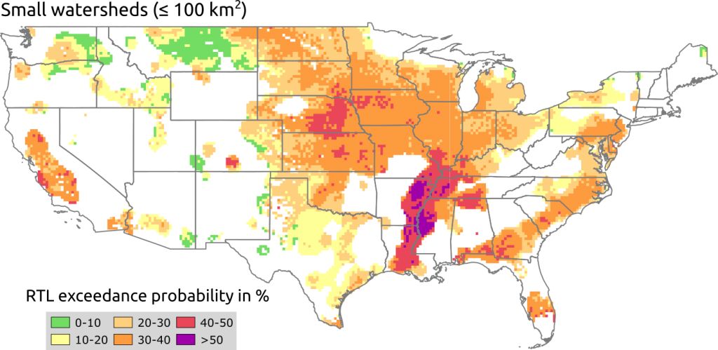
While we saw a slight decrease in overall risks over time, the current interaction of spatio-temporal factors still results in widespread occurrence of insecticides reaching hazardous concentrations in receiving water bodies. This was shown with our model on the national scale, which, for the first time, provides comprehensive risk estimation for various agricultural insecticides and considering more than 2.6 million stream segments in the United States (see figure to the right).
As expected, risks were most pronounced in smaller watersheds where half of the total stream length in the U.S. experienced at least 27.7% of RTL exceedances in 2017. Considering that these small waterbodies constitute six times more stream lengths than all the remaining water bodies combined, underlines the widespread impact that insecticides have on these ecologically important upstream ecosystems.
Finally, the video below provides an overview on how insecticide risks have evolved spatially over the last 15 years in small U.S. surface waters and more interactive results can be found here.
In this study, we also provide more detailed analyses regarding risks in sediments and the potential risks of co-occurring insecticides (i.e. mixture toxicity), which you can also read up on, if you are interested.
The paper was published by Jakob Wolfram, Sebastian Stehle, Sascha Bub, Lara Petschick, and Ralf Schulz in Environmental Science & Technology. Additionally, some interactive analyses can be accessed online here and interactive maps can be found here. Figures are reprinted with permission from American Chemical Society in 2019.
